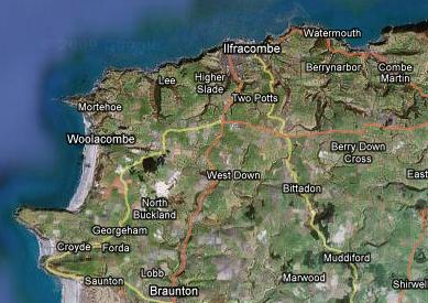
Combe Martin – Saunton

Last night I kept waking up, but generally I had an ok sleep. The day started at 6.45. I walked out of Combe martin and about 20 minutes later I got lost in a holiday park, which the Path happened to cross. There was a little gate which I didn’t notice and kept walking around the park looking for an exit. I found the exit and followed some road. After about 100 meters I found an acorn waymark, followed it and ended up walking back in to the holiday park through the gate mentioned earlier. That really confused me and so I kind of walked around the park for a wile. Soon I realised that I was supposed to leave the park through the gate, and then follow the road that I just came from. I felt stupid:)
It was another fine morining and I was beginning to get suspicious about the weather, something wasn’t right! It was low tide, so I walked right through the harbour:

I saw some pretty awesome views that morning:


Up to this point I was doing pretty good in terms of general health and fitness. Suddenly that started to change. By about 9 a.m. I already had three potential patients:) – left foot, left knee and right ankle. After a couple of hours the ankle took a definite lead and I began to feel actual pain. I wrapped my bandana (which I nearly left at home) around the ankle to give it support and it worked reasonably well. My average speed decreased though.
By lunchtime I got to Ilfracombe, which is located along a very long beach. I was quite surprised to see armies of surfers, as I never realised that UK was into that kind of stuff. I dropped by a supermarket to restock on snacks. I also got a baguette, milk and a lemon which served as lunch. I had a good rest on the beach (about an hour) and then resumed walking. The ankle was doing ok and the rest of the day went down smoothly. I think it was then I first started eating blackberries. By 6 p.m. I reached a huge bay which started of with Saunton beach:

At this point I had no idea that I would spend the whole of next day getting to the other side of the bay. I mean it was big, but I was quite certain that I would get out of it by lunchtime next day. I still had about 1.5 hours of daylight left, so I decided to press on. Suddenly, instead of going along the beach the Path started going inland, which again confused me. As it turned out there was a reason for this – the bay had a river mouth (you can see it on the photo above, but I missed it):

At about 19.30 I decided to call it a day. As you can see on the map I was walking along the sand dunes (south) which were on my right. On the left there was endless fenced private farmland. The dunes were marked as army shooting range, but I went for it and set up camp just before sunset. The weather was perfect still and I started toying with the idea of sleeping under the stars. It didn’t take me long to convince myself, so I laid the tarp on the ground and arranged the bivy on top. I quickly had a noodle, some snacks and tea and fell asleep…
Leave a Comment so far
Leave a comment